
The Mountain the Algorithm Built
When Instagram Meets 5,200 Feet of Elevation Gain

Heavy breathing, flushed cheeks, and musky sweat clinging to skin, all set to the muffled hum of reggaeton. I’m in Guatemala—but not at a colorful youth hostel. Instead, I’m on a trail heading toward an active volcano. Half of Gen Z and I seem determined to climb a mountain today.
I’ll be perfectly honest, I discovered the Acatenango summit hike—with its iconic views of its active volcano neighbor Fuego—on Instagram. The last time I visited Guatemala was before social media existed and Tikal was the tourist hot spot. With Instagram imagery shaping travelers’ bucket lists, it’s no wonder hundreds of us were huffing and puffing our way up the steep slopes.
While Acatenango and Fuego may be Instagram darlings, those iconic shots come at a high price. An elevation gain of 5200 feet in 6.5 km is no joke. But in a country where residents are desperate for cash in their pocket, it’s easy to book, pay, and embark on the experience without realizing what you’re really getting yourself into.
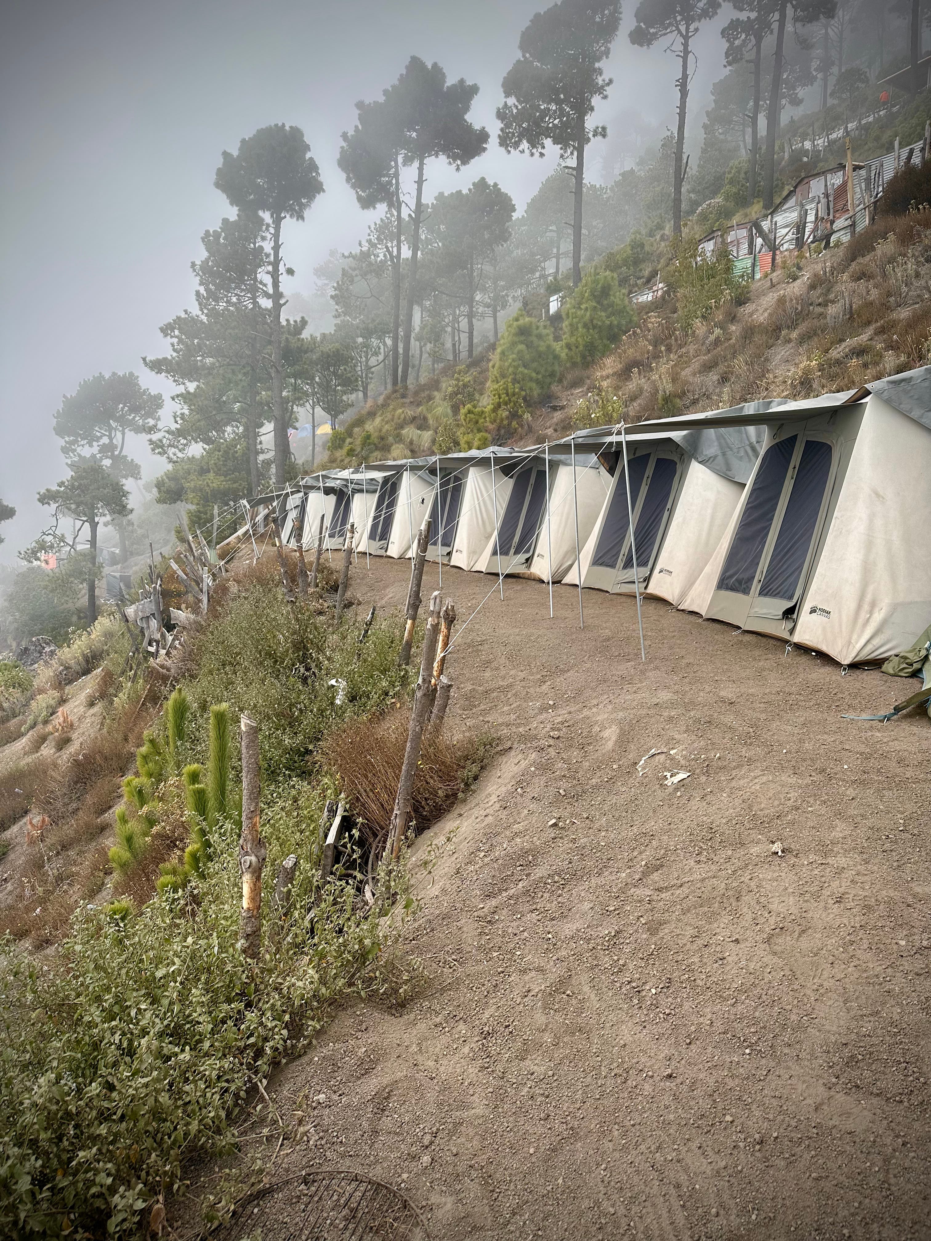
Most hikers depart mid-morning, aiming to reach “base camp” by mid-afternoon. Base camp sits approximately 1,000 feet below Acatenango’s summit, with various tour companies operating their own designated sites. I asked around but couldn’t get a clear answer on ownership; I was told some camps sit within the National Park while others are on private land. What is clear is that money changes hands somewhere, as the most prime locations offer the best views and accommodations.
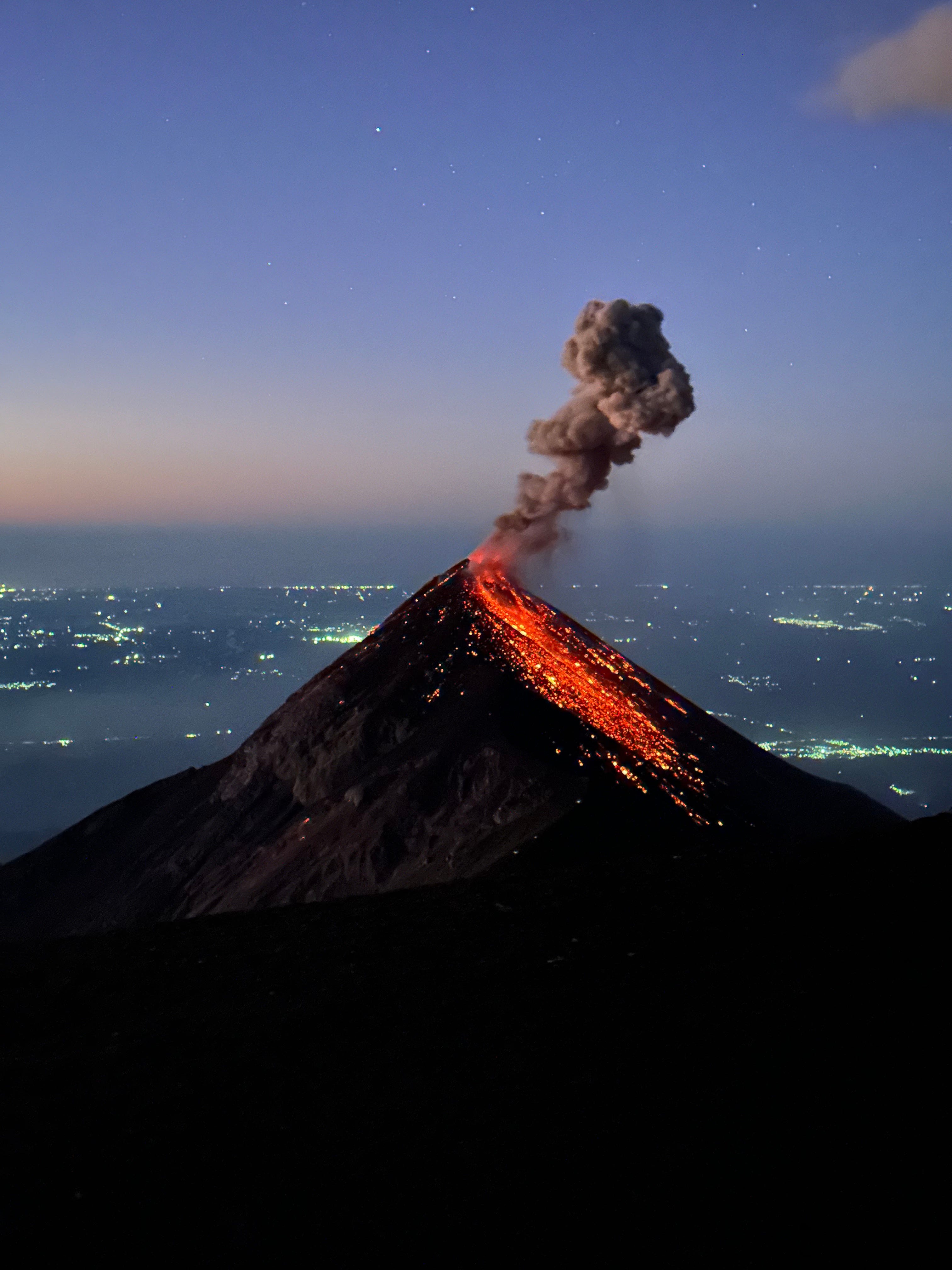
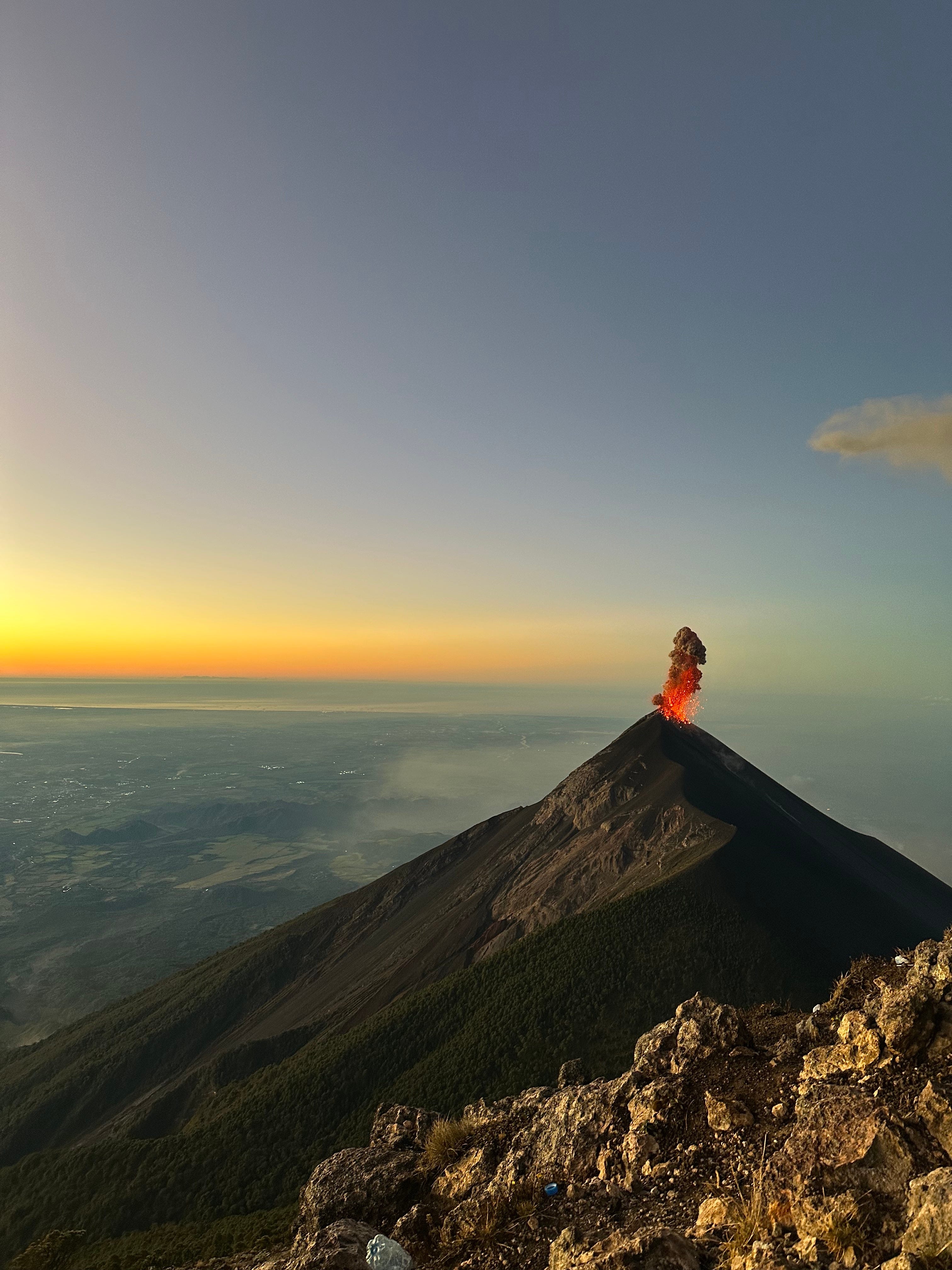
Perched on Acatenango’s steep slopes, base camp looks out toward Volcán Fuego, which is connected to its neighbor by a thin ridge. Belching ash, hurling rocks, and spewing lava, Fuego and her fireworks are the stars of the show. Ambitious hikers can trek from base camp back downhill and steeply climb onto the connecting ridge for a closer view. The last person who hiked too far and too close lost an arm to flying molten volcanic rock.
Base camps vary from weather-worn tents to glamping accommodations and plywood A-frame cabins. Ours, small and well-constructed, was well-suited for the mature-by-comparison crowd it hosted. Our glamping tent even featured a plastic potted plant. Stray dogs make the trek up the mountain with ease, providing scruffy comfort after a long day.
Temperatures drop quickly at an altitude of over 12,000 feet, and campers congregate around the campfire to watch Fuego light up the sky. The real magic happens after dusk, when vibrant orange lava tumbles down Fuego’s slope—perilously close to the line of hiker headlamps illuminating the ridge. The hike to the ridge is considered safe, but from a distance, it appears to be a stone’s throw from death.
Sleep is hard to come by, but that’s part of the appeal. Dull altitude headaches compete with the urge to stay within the sleeping bag’s warm confines rather than face a cold trudge to the outhouse. When slumber does come, it is often disturbed by cannonball booms and blasts that Fuego seems to have saved for the early morning hours. Sound shock waves rattle the tent, and small tremors send cascades of rocks scurrying past the canvas walls.
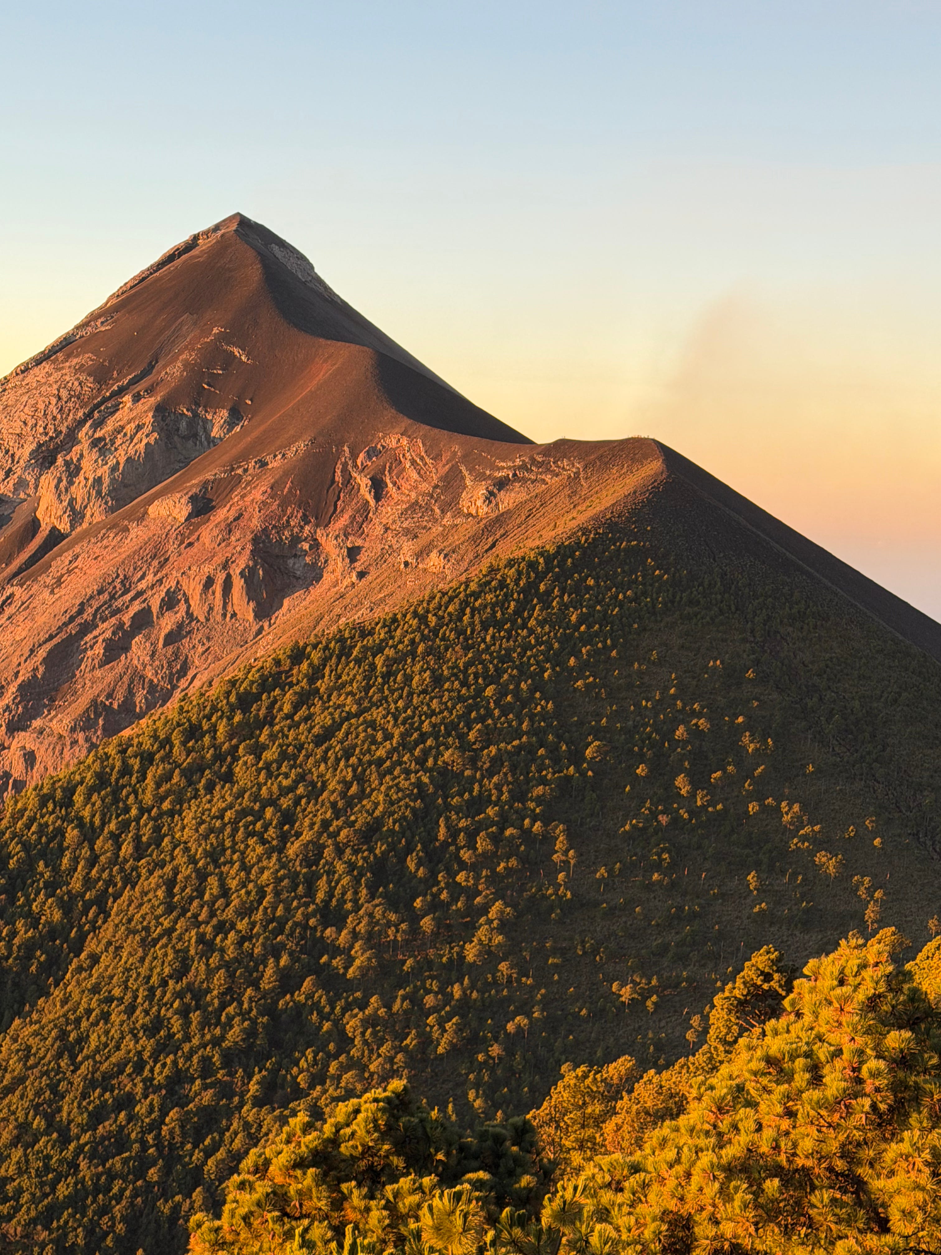
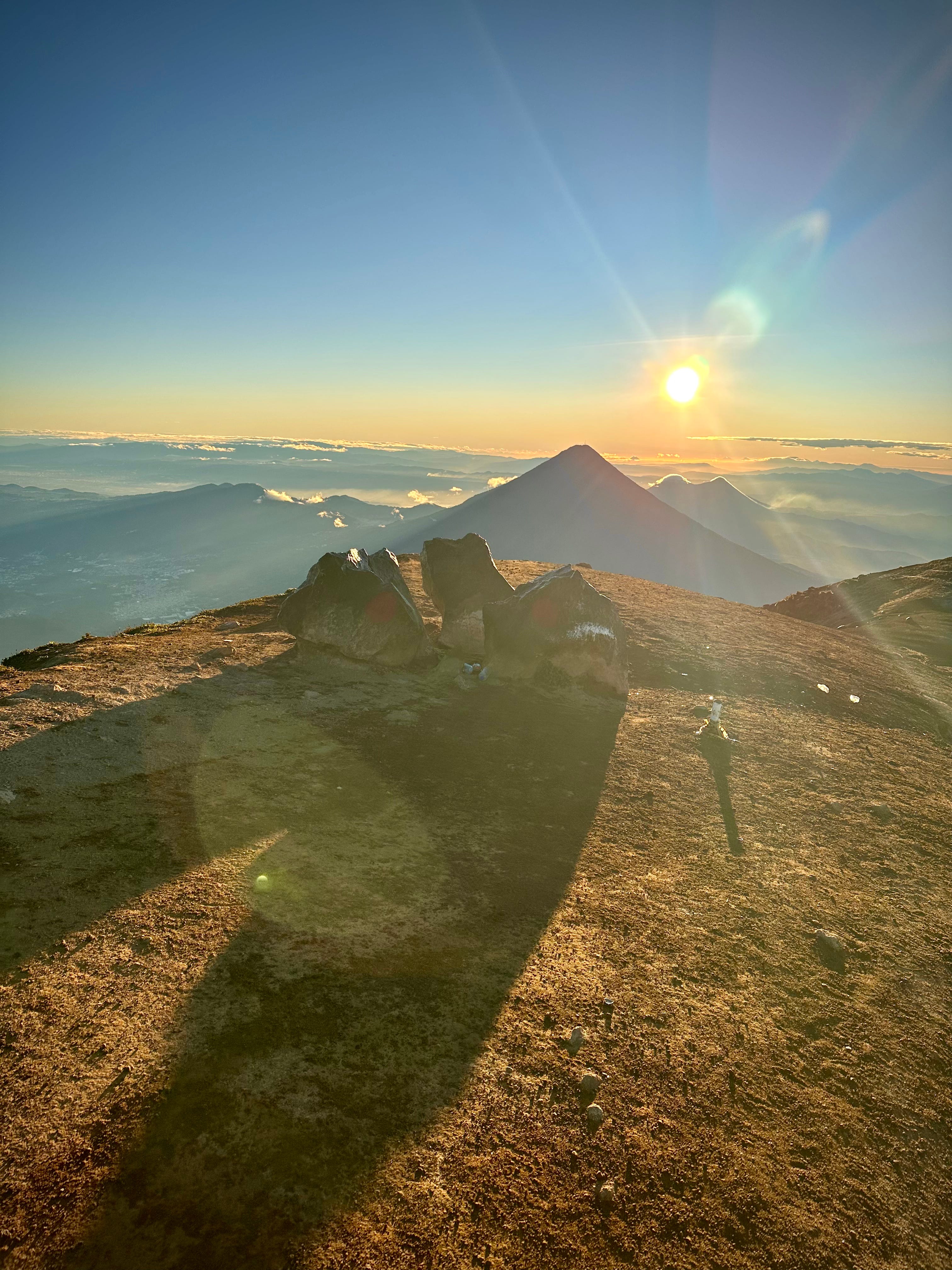
The wake-up call is set for 4:00 a.m. Most hikers opt to summit Acatenango for sunrise, but it’s a tough slog; it’s three steps forward and two steps back as the steep, black volcanic scree gives way beneath your feet. Breath is hard to come by, and some hikers—defeated by the incline—return to base camp before reaching the top.
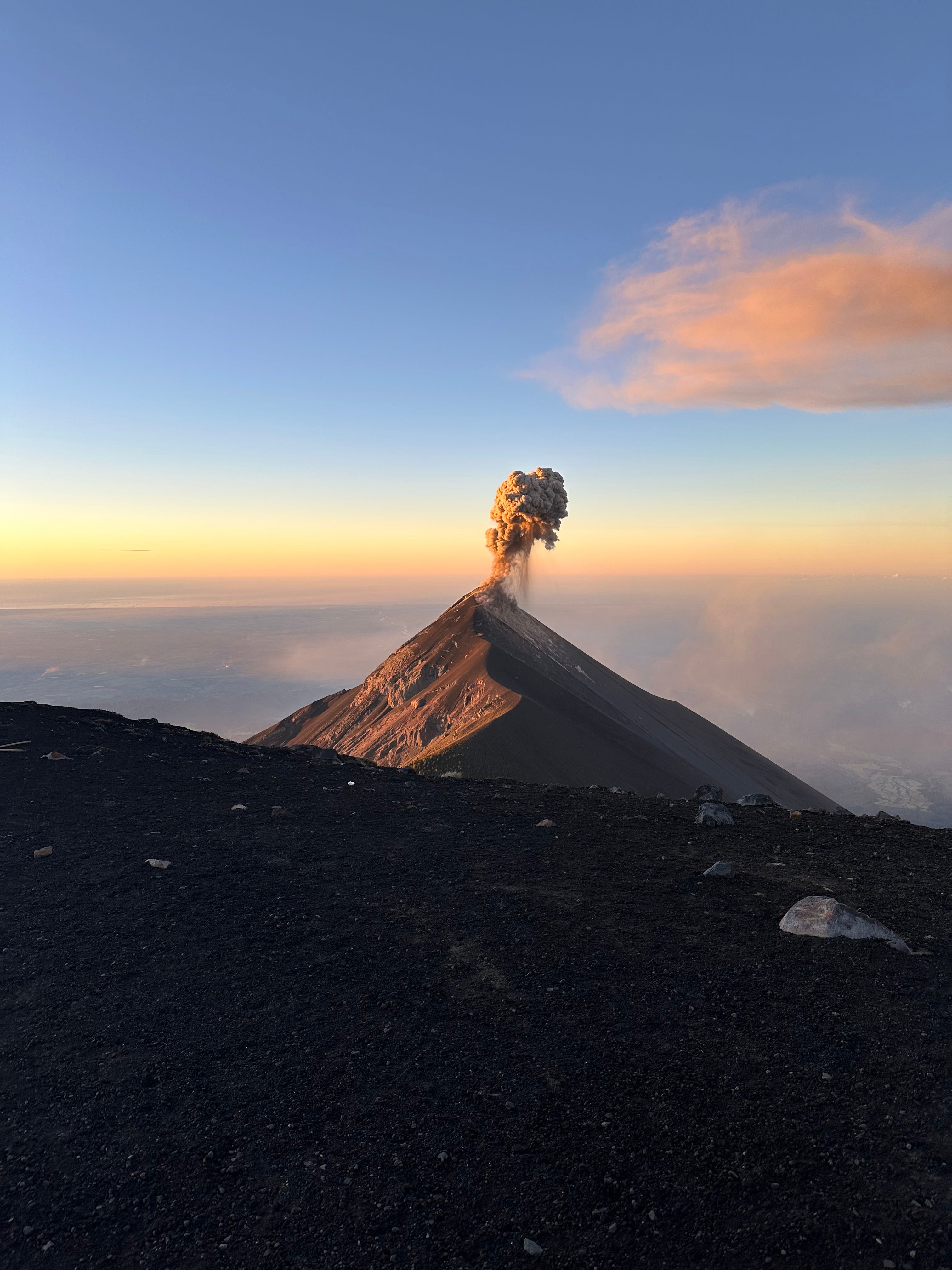
Reaching the summit is an achievement quickly blunted by the wind. Piercing and ice-cold, it demands every layer you brought on your supposed tropical vacation. My guide and I made good time—the first from our base camp to arrive—and were among the first to stand on the summit crater. We agreed to witness one blast from Fuego before retreating into the limited shelter of Acatenango’s crater. Being fast up the mountain meant an hour-long wait in the wind-catapulting cold before sunrise.
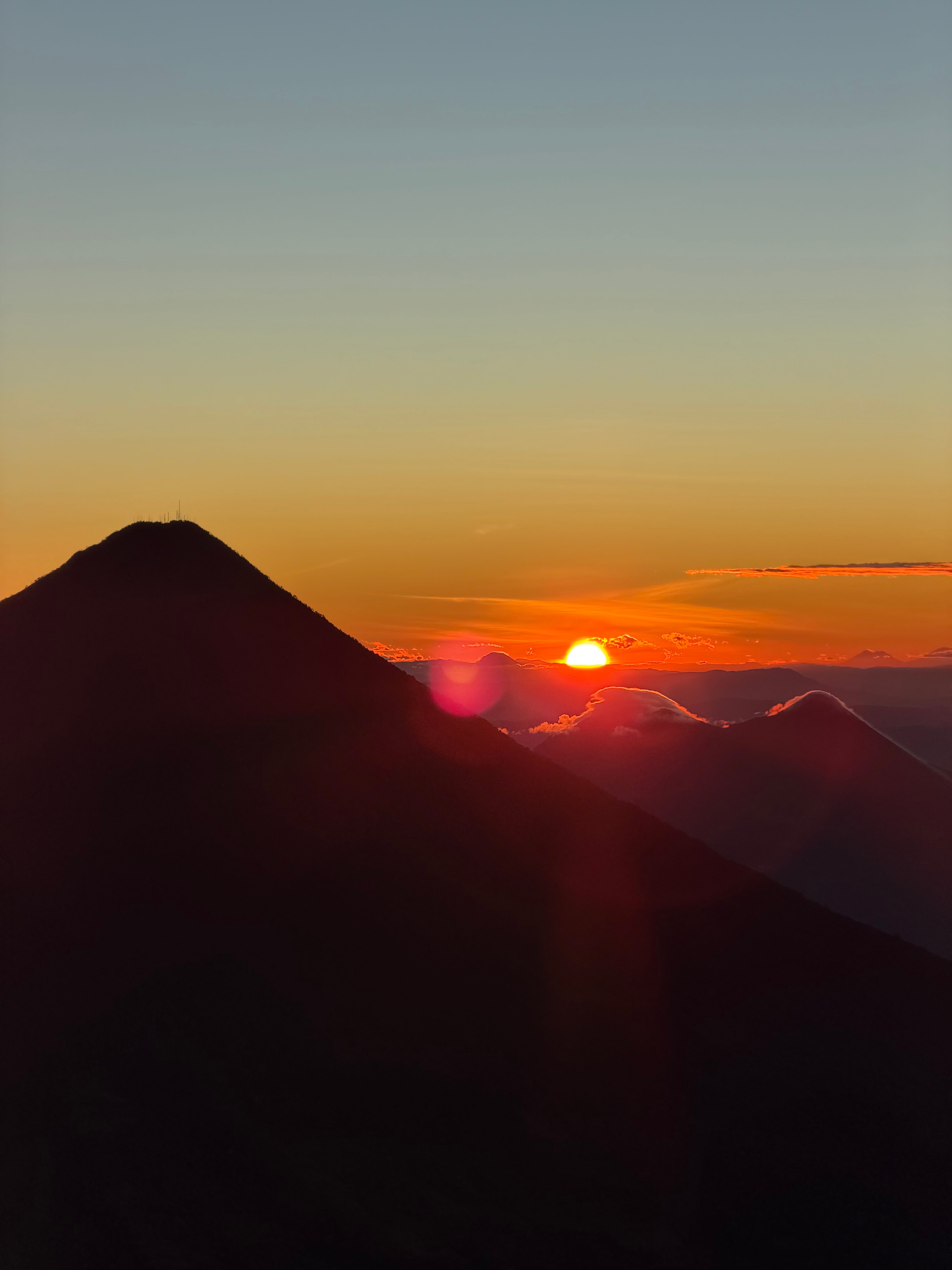
Witnessing sunrise on the mountain is a holy experience. With views stretching from Guatemala City to the Pacific, the day’s first rays illuminate the country’s vast, scenic landscape. The rising sun is perhaps the only thing capable of distracting from Fuego’s pyrotechnics.
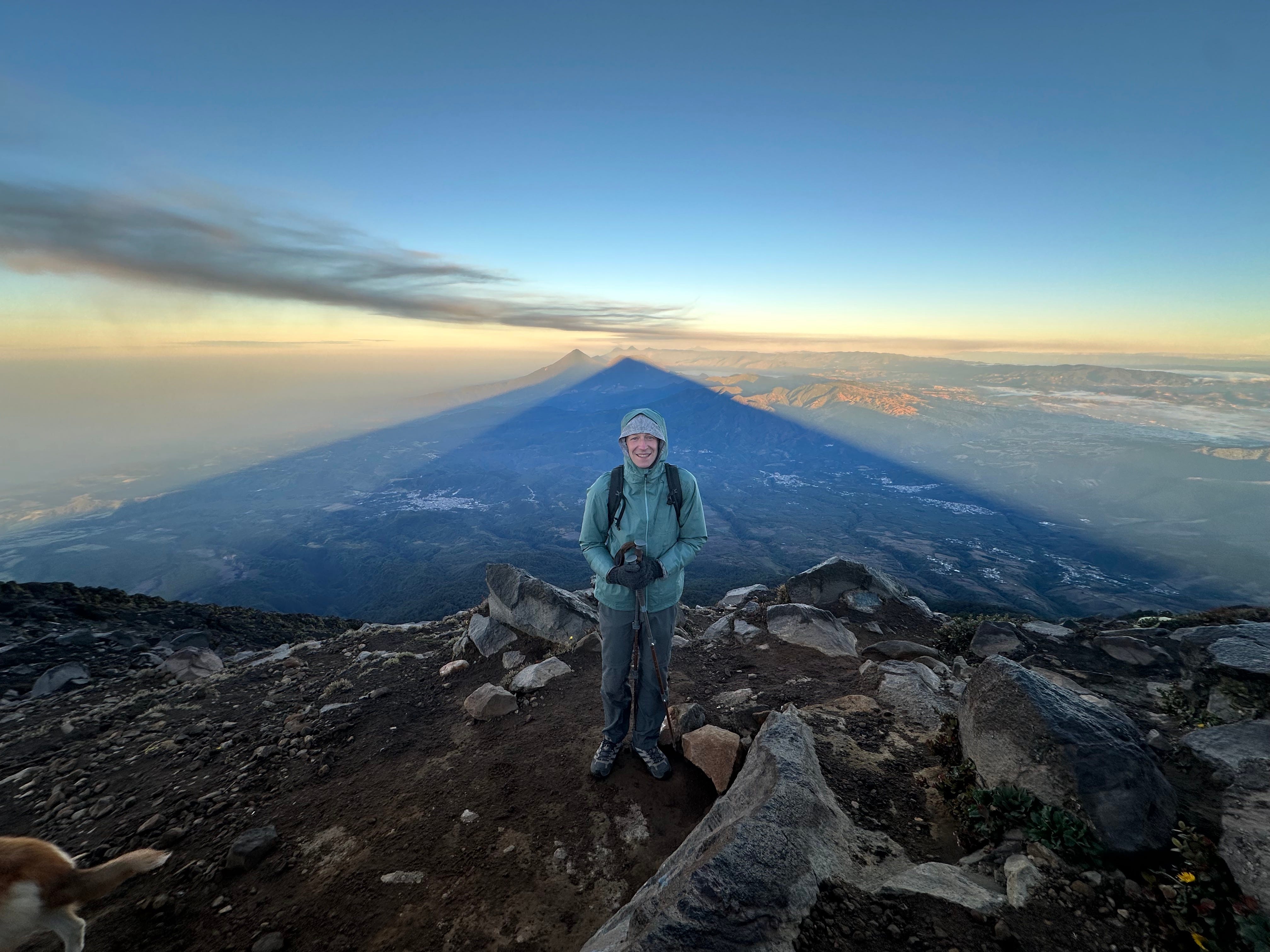
Most hikers retreat to the relative warmth of base camp immediately, but hiking around the crater and upward, past steaming fumaroles (which serve as welcome hand warmers), leads you to the true summit of Acatenango. Timed correctly, and looking north—a direction most fail to notice due to Fuego’s southern position—Acatenango’s massive triangular shadow shades Lake Atitlán and the surrounding land. It is a mythical shape from the cosmos, like a shadow cast by an alien spacecraft.
If you’re lucky, a stray dog from base camp will lead you on the quick descent. Like riding an escalator, the volcanic sand gives way beneath your feet, making it feel as if you’ll take the whole mountain down with you. Once shoes leaden with sand are emptied, feeling finally returns to your fingers and nose. Back at base camp, breakfast awaits.
The descent down the rest of Acatenango proceeds quickly, albeit painfully on the knees, as the steep slopes hurtle you downward. The more you resist the gravity, the harder it becomes to stay upright. The final kilometer, passing through steep, exposed farmland, makes memories of the morning’s frigid cold evaporate. Apparently, the first group down the mountain receives coffee and cake, fresh from a family kitchen—a reward we discovered while waiting for the others from our camp to arrive
Trash litters the trail, and entrepreneurial vendors populate every plateau. Good guides—and good hikers—pick up what they can en route, but most visitors seem unfocused on the journey, rapt instead on the final photo. As companies grow desperate for business, they take larger and larger groups. Many people hike disconnected from the cloud forests and the high alpine pines, wearing noise-canceling headphones or carrying boomboxes carabiner-clipped to their backpacks. Acatenango is no longer treated as a sacred mountain; she is a moneymaker and a money shot.
A perverse pleasure exists in watching the realization of what must be endured sink into the eyes of ill-prepared hikers, followed by the slow drop-off of the crowd toward the summit. In all fairness, as an avid hiker, it was Instagram that led me to Acatenango and Fuego—and for that, I am grateful. Spending 14 hours perched on those slopes, enraptured by Fuego’s luminous display, remains one of my most cherished travel memories. I’m glad it was hard—f***ing hard work.
Guatemala is fast becoming the “place of the year” for Central American travelers, and with that social-media-driven popularity comes opportunity. There is space for all of us on Acatenango’s wide trails and terraced base camps, but there is also an opportunity to aid in removing the trash from her slopes. It is a chance to support the community through local vendors and tour operators, and an opportunity to acknowledge that Fuego and Acatenango aren’t just there for the “show.” They are sacred symbols of Guatemalan identity and indigenous heritage—stark reminders that we are merely guests on a living, breathing planet.
Need to Know
Acatenango Volcano is located near Antigua, Guatemala, and is most commonly climbed as an overnight hike to view eruptions from neighboring Volcán Fuego.
Elevation gain: ~5,200 feet (1,600 meters)
Distance: ~6.5 km (4 miles) to base camp
Altitude: ~13,045 feet (3,976 meters) at the summit
Difficulty: Strenuous
This is not a casual hike. Steep volcanic scree and high altitude make it physically demanding.
Prices range greatly from $50 per person (shared tents, basic food etc.) to over $350 per person (private accommodation, better gear etc.)
Avoid companies that run excessively large groups.
Don’t confuse “popular” with “easy.”
If we haven’t met yet, I’m Richard Philion. I traveled the world during my dance career and continue to explore with the same passion. If you love adventures to both new and familiar places, I’d love to connect and share our mutual love for travel. Through the Travelling Troubadour, I hope to inspire and inform with stories, tips, and itineraries.
Feel free to message me directly—I’d love to meet you.
Wow, what an adventure, what a climb, what gorgeous sights!! Thank you for sharing your experience (and for picking up some trash!)!
It was nice to actually read about the Acatenango experience instead of just seeing it on socials. We were in Guatemala in 2022 and opted not to do the hike, mostly because both me and my partner got sick and didn’t feel fit enough to hike.
Im a big proponent of hiking within ones means so to this day i dont really regret missing out on this, however epic it looks.